
Italy is not just about historic town squares. If you prefer the crunch of hiking boots on rock to the drone of tour groups in line, head straight for the Furlo Gorge. Here, in the inland Marche, the Candigliano River has carved a sheer limestone canyon between Mount Pietralata and Mount Paganuccio over millennia. The result is a vertical corridor where nature and history collide without any commercial filter. This is the domain of raw stone.
Forget about viewing platforms with elevators. The first time I climbed toward the summit of Pietralata it was dawn, my legs burning on the gravel switchbacks and my hands cold against the rough limestone. Just as I paused to catch my breath, a golden eagle cut through the clear air above the canyon and glided over the green waters of the Candigliano, and that sight wiped away every drop of sweat in a second.
Why Furlo Gorge is Worth the Effort#
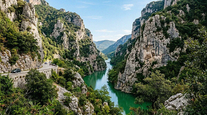
The canyon is a scar of ancient rock. The vertical walls rise for hundreds of meters straight up from the green waters of the Candigliano River. For hikers, this means demanding routes with passages over loose stones and rocky steps that require absolute concentration. From the summit, the view stretches from the ridges of the Apennines to the Adriatic coast on the clearest days, and the sense of vertigo is a certainty here.
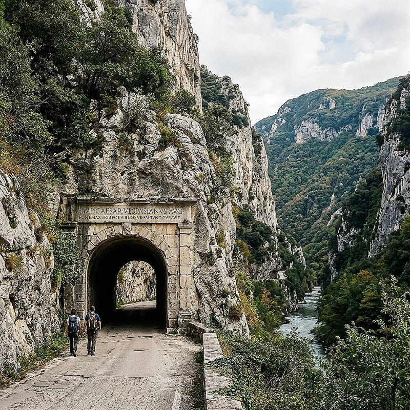
The stone guards ancient memories. Walking through the gorge, you realize how hard human ingenuity had to fight against the hardness of the limestone. Emperor Vespasian had a tunnel cut through the narrowest point of the gorge to ease traffic along the Flaminia. If you want to pair Roman engineering with Renaissance contemplation, the ideal geometry of Urbino and the Ducal Palace is a short drive away, and here history is trodden underfoot.
- Real, wild nature: The smell of damp earth and wildflowers fills the air, while below you the Candigliano, held back by the dam since 1922, widens into a calm lake between the walls it carved over millennia. Keep an eye out for the golden eagle nesting on the cliffs of Pietralata or roe deer in the undergrowth.
- Time travel on foot: The Roman Via Flaminia and the Flavian-era tunnel stand as physical testaments to centuries of travelers. Walking through the Roman tunnel gives you a physical connection to the past (but read the update below before you go).
- Sweat-worthy challenges: Biking or hiking, the steep slopes demand respect and proper preparation.
Stop making absurd comparisons. Hearing this Marche gap described as “Italy’s Grand Canyon” makes me roll my eyes every single time. The gorge has its own distinct geological identity made of dense woods, holm oaks clinging to the cliffs, and emerald water. You do not need American labels to give value to a territory that possesses such a sharp and defined personality, because Furlo stands perfectly well on its own.
Getting There: No Shortcuts, No Excuses#
Reaching this corner of Italy requires planning. Do not expect tourist buses or convenient train stations to drop you steps from the trailhead. You need to get here on your own, studying road maps and preparing to navigate the secondary roads of the Pesaro hinterland. The few free parking spaces near the reserve fill up quickly from the early morning hours on summer weekends. Plan ahead or you will be stranded.
By Car#
A car is your only real option. From the A14 highway, take the exit for Fano and merge onto the SS3 Flaminia highway toward Rome. Keep driving up the Metauro Valley past Fossombrone until you reach the exit for the reserve. The road narrows progressively until it enters the limestone walls where the tiny village of Furlo lies. The journey begins from the windshield.
Public Transport#
Forget about trains entirely. In this valley, the only railway has been out of service for years, and there are no active stations nearby. The local concept of a “station” refers to the ancient Roman post houses where horses were changed along the Flaminia road. If you choose to use public transit, expect long bus rides from Fano or Urbino with very limited service on holidays. The train does not run here.
Your Starting Point#
The focal point is the visitor center. Located in the small hamlet of Furlo at Via Flaminia 36, the office provides essential information on trail accessibility. The local staff will point out any temporary closures due to recent landslides or nesting birds of prey. Buying a detailed paper map here is your best move before entering the woods. Do not rely solely on your phone.
Stop by the visitor center before starting. Trails change frequently due to landslides or weather, and the updated paper maps you find here are more reliable than the GPS signal in the gorge.
You can never have too many warnings. Many weekend walkers tackle Pietralata thinking it is a casual stroll behind the house. When they realize the signs are faded or the rock walls block their phone signal, the situation gets serious. Gathering fresh data on trail conditions will save you from an awkward call to the local alpine rescue team, since caution prevents serious trouble.
What to Do at Furlo Gorge#
The gorge requires a slow pace. Every single crack in the limestone-clay rock hides fossils or traces of ancient travelers. If you race to reach the top, you will miss the most intimate details of this natural corridor. Stop to listen to the gurgling Candigliano River echoing between the gray stone walls. The secret is to slow down.
Landmarks You Can’t Miss#
- Vespasian’s Tunnel: This Roman passage of about 38 meters was carved into the limestone in 76 AD to facilitate travel along the Flaminia. Look for the smaller, older tunnel nearby, which dates back to earlier periods and is likely of Umbrian or Etruscan construction.
- Furlo Dam: The artificial barrier on the Candigliano River creates a narrow, emerald-green basin enclosed by vertical rock walls.
- Abbey of San Vincenzo al Furlo: An abbey documented since 970, with the church rebuilt in 1271 after a fire (the inscription on the portal lintel records it), along the route of the Flaminia.
- Giants’ Potholes of Fossombrone: Cylindrical cavities carved into the rock by the Metauro River near Fossombrone, a few kilometers downstream of the reserve.
- Furlo Terrace: A panoramic viewpoint on Mount Pietralata reached by trail, offering a sheer view over the gorge below.
- Testa del Duce: A rocky profile of Mount Pietralata shaped in the 1930s by the Forestry Corps to reproduce the features of Benito Mussolini, then mined and destroyed by partisans during the war: today it is only partly recognizable.
Trails and Adventures#
This terrain does not tolerate lack of preparation. The steep slopes and loose scree test your leg muscles and knee joints. Do not think of tackling the tougher climbs in footwear that lacks a rugged sole designed for uneven terrain. Without proper cardio conditioning, the climb will quickly turn into needless suffering, so respect it from the first step.
Hiking Trails#
The trail network offers varying difficulties. Casual walkers can stick to the flat, paved old Flaminia road, which is also suitable for strollers and older travelers. Those looking to test their legs will head for the CAI paths climbing the main peaks. If you’d rather balance inland cliffs with a salty breeze, also explore the sea-cliff trails of the Conero Riviera. Choose your trail with your head.
- Old Via Flaminia Trail: A flat, paved path of about 3 km running along the Candigliano River, ideal for an easy walk accessible to everyone.
Update: after the rockfall on the evening of 9 September 2026, ordinance no. 26 of the Municipality of Acqualagna and ordinance no. 86 of the Municipality of Fermignano (10 September 2026) ban vehicles, bikes and pedestrians from the stretch of the Flaminia inside the gorge, tunnel included. Before you go, check the Reserve’s website (riservagoladelfurlo.it) to see whether the ban is still in force.
- Mount Pietralata trails: Climbing Mount Pietralata (889 m a.s.l.) means about 700 meters of elevation gain from the valley floor, on steep slopes over gravel and rocky steps (CAI difficulty E). Across the gorge rises Mount Paganuccio (976 m). For up-to-date trail numbers and routes, use the Reserve’s hiking map, which covers about 52 km of trails.
Personal note: For the love of all that is sacred, do not show up on the Pietralata trails in flip-flops or smooth-soled running shoes. I have had to watch casual tourists slide around helplessly, risking real injury. Also, remember to pack at least 1.5 liters of water, as there are no springs or fountains along the climb.
Mountain Biking#
Knobby tires require self-control. The dirt trails climbing both sides of the gorge offer slopes that test your brakes and tire traction. Do not use these paths as downhill tracks to break personal records on tracking apps. Encountering hikers at crazy speeds on narrow passages is the best way to cause a serious accident. Slow down in blind spots. And remember that in the most protected zones of the Reserve, bikes are allowed only on trails and roads designated by the park authority: check the Reserve’s rules before you set off.
River Activities#
The river offers a different perspective. Gliding on the calm waters of the Candigliano in a canoe or kayak, where and when the Reserve allows it (only on the stretch upstream of the dam basin), lets you observe the gorge from its lowest point. The massive limestone cliffs seem to close over your head as you paddle in silence. The rhythmic sound of your blades in the green water is the only sound allowed in this reserve, a chance to experience the canyon from below.
Refuel Like a Local#
Physical effort brings a fierce hunger. Nearby Acqualagna is nationally renowned for harvesting prized white truffles and summer black truffles (scorzone). The area’s historic trattorias serve rustic first courses perfect for restoring the minerals and calories burned on the trail. Pair your meal with a glass of fresh Bianchello del Metauro or Colli Pesaresi Sangiovese, and you will swear that truffles cure every cramp.
- Antico Furlo Restaurant: Located right at the entrance of the gorge, this is the gorge’s historic inn, with local cooking built around truffles.
- Ristorante Tartufo (Acqualagna): At Viale Risorgimento 1, serving local specialties centered on truffles.
- Plinc Braceria Osteria (Acqualagna): A grill house for when you want meat off the coals after the climb.
- Agriturismo Agri Campagna (Acqualagna): Home-style country cooking in the hills between Pigno and Monte Martello.
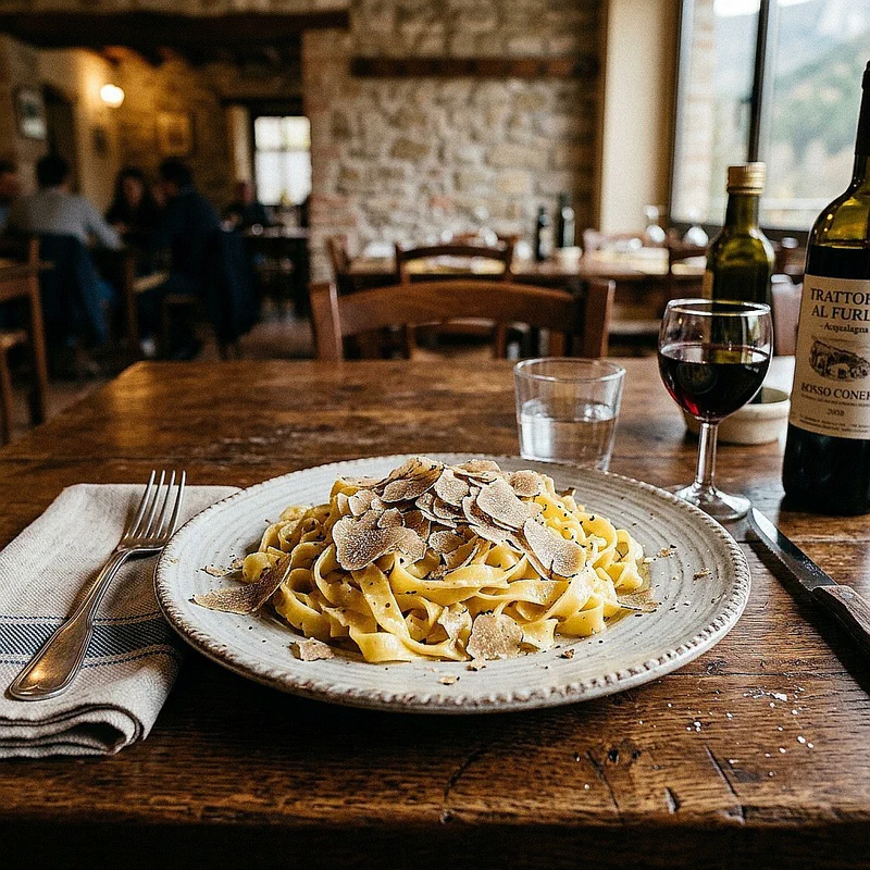
The meal brings a fitting end to the day. Eating with tired legs under the table and the aroma of formaggio di fossa and mushrooms in the air is the true reward of the hiker. From the trattoria window, you can watch the rocky ridges fade into the blue of twilight. You will realize that every drop of sweat shed on the trail was worth this moment. This is Marche hospitality.
My Rules for a Good Time in Nature#
The reserve demands strict rules. Do not venture onto the trails without planning your route and check-in points. Check local weather forecasts because Apennine storms can turn dry rock into a slippery slide in minutes. Always carry a headlamp and a basic first-aid kit in your pack for emergencies. Respect the mountain at all times.
- Leave no trace: Pack out all your trash, including organic waste like peels or cores, which alter the local ecosystem.
- Turn off the music: Avoid Bluetooth speakers or loud phones; the silence of the gorge should only be broken by the river and the wind.
- Trail etiquette: Uphill hikers have the right of way, and cyclists must always yield to pedestrians, stopping if necessary.
The gorge makes no compromises. This Marche reserve welcomes only those willing to trade artificial comforts for raw nature. Bring your stamina, geological curiosity, and deep respect for the local wildlife. If you want terrain even more severe than the Apennines, put the Ligurian Alps hikes in Valle Pesio on your list. Hike and learn to hold your tongue.