Ciao! I’m Martina. While others are sleeping in, I’m usually lacing up my boots or checking my tire pressure to catch the first light on a peak. From the vertical walls of the Dolomites to the hidden MTB trails of Umbria, my life is measured in elevation gain and the rush of the descent. I’m here to show you the ‘wild’ Italy—the one that requires a bit of sweat to reach, but offers views that stay with you forever. Since writing this, my colleague Giulia explored the culinary side of Umbria, discovering the region’s hidden gems and must-visit food and wine destinations on her Savoring Spring in Umbria: A Food and Wine Journey Through Italy’s Green Heart Umbria’s Tastiest Roads. Let’s hit the trail, but remember: leave nothing but tracks.
You think you know Monte Rosa? Think again. Beyond the well-trodden paths of Cervinia and the bustling ski resorts, lies a network of secret valleys in Valle d’Aosta, waiting for the intrepid soul ready to earn their views. This isn’t your postcard Italy; this is the raw, untamed heart of the Alps, where Walser culture thrives and the silence of the mountains is broken only by the wind and the distant call of a marmot. Since writing this, my colleague Giulia has delved deeper into the region’s culinary secrets, exploring the flavors of Valle d’Aosta’s traditional Walser cuisine in her recent guide A Taste of the Mountains: Discovering Valle d’Aosta’s Hidden Culinary Gems.
If you’re seeking authentic, insider-led advice to truly experience the ‘real’ Italy—the one that demands effort but rewards with unparalleled beauty—you’ve come to the right place. Forget generic tours; we’re diving deep into the less-known alpine treks that will challenge your body and rejuvenate your spirit.
The Lys Valley’s Hidden Gems: Trekking Around Gressoney#
The Lys Valley, or Valle di Gressoney, is a testament to the resilient Walser people and their ancient traditions. It’s a place where stone and wood houses cling to the mountainsides, and the air is crisp with the scent of pine. While Gressoney-La-Trinité is a starting point for many, we’re venturing a little higher, a little deeper.
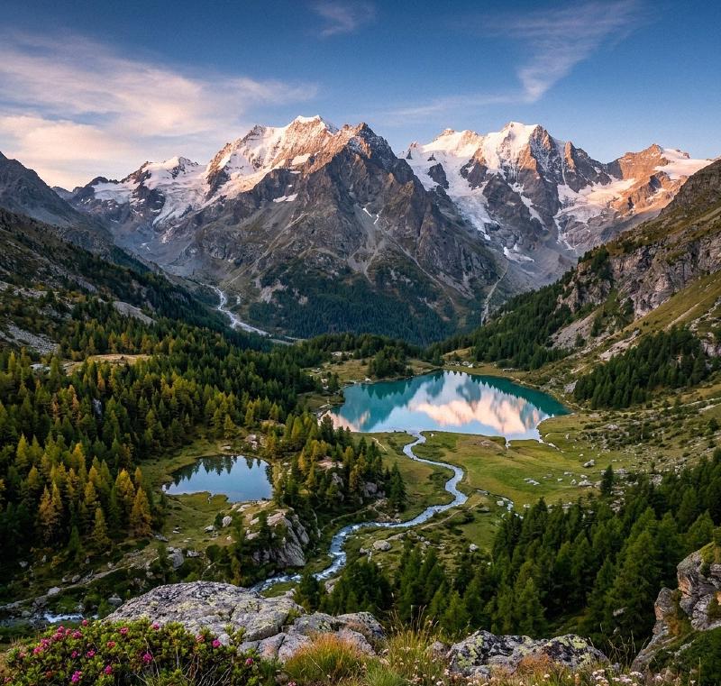
Trek: Lago Gabiet & Passo dei Salati Loop#
This demanding, yet incredibly rewarding, loop begins in Staffal, the highest hamlet of Gressoney-La-Trinité. You can opt for the cable car to Rifugio Gabiet (2375m) to save some vertical, but for those ready for the grind, the ascent on foot is part of the journey. From Rifugio Gabiet, follow the path (often marked as CAI 6A) towards Passo dei Salati.
- Starting Point: Staffal (Gressoney-La-Trinité), at approximately 1825m.
- Destination: Lago Gabiet (2375m), Passo dei Salati (2980m).
- Difficulty (CAI): E (Escursionistico), with sections leaning towards EE (Escursionisti Esperti) if tackling the full elevation gain without lifts.
- Elevation Gain (D+): Approximately 1100m for the full loop from Staffal to Passo dei Salati and back.
- Distance: Around 10-12 km, depending on the exact route and whether lifts are used.
- Estimated Time: 5-7 hours.
The trail winds through high alpine pastures, offering increasingly panoramic views of the Monte Rosa massif. The final push to Passo dei Salati, a natural saddle between the Lys and Valsesia valleys, reveals a breathtaking vista. On a clear day, you can even spot Lake Maggiore in the distance. Believe me, the burn in your quads is worth every drop of sweat when you reach that summit!
Post-Hike Fuel: After descending, treat yourself to authentic Walser cuisine at Ristorante Walser Stube in Gressoney-La-Trinité, known for its traditional dishes, or grab a hearty meal at Ristorante Nordkapp in Staffal.
The Ayas Valley’s Rugged Trails: Ascending Towards Grand Tournalin#
The Val d’Ayas, with its charming villages like Champoluc and Antagnod, offers a different flavor of alpine adventure. It’s a valley less about the sheer magnitude of glaciers and more about rugged trails leading to iconic refuges.
Trek: Ascent to Rifugio Grand Tournalin#
This trek is a classic for a reason, but it’s far from a stroll. Starting from the picturesque hamlet of Saint-Jacques, the trail steadily climbs through larch forests and open alpages, eventually revealing the majestic Rifugio Grand Tournalin perched at 2535m.
- Starting Point: Saint-Jacques (Ayas), at approximately 1689m.
- Destination: Rifugio Grand Tournalin (2535m).
- Difficulty (CAI): E (Escursionistico). While not technically difficult, the sustained ascent requires good physical condition.
- Elevation Gain (D+): Approximately 846m.
- Distance: Around 10 km (round trip).
- Estimated Time: 4-6 hours (round trip).
The path, well-marked, offers glimpses of the Matterhorn and other towering peaks. The tranquility up here is profound. The mountain doesn’t care about your followers, respect it with every step, and it will reward you with silence and views that cleanse the soul. Look out for drinking water sources along the way, especially at Rifugio Grand Tournalin.
Post-Hike Fuel: In Champoluc, Lo Rétsignon (accessible via the Frachey funicular) is a solid choice for traditional Aostan food. If you’re looking for something with a charming atmosphere, head to Le Cadran Solaire in Antagnod, offering typical Valdostan cuisine with a focus on local products.
Essential Gear for the Ascent: Martina’s Must-Haves#
Before you even think about hitting these trails, let’s talk gear. This isn’t a walk in the park; these are alpine environments where conditions can change in a heartbeat.
- Sturdy Hiking Boots: Non-negotiable. Ankle support and good grip are paramount. Honestly, if I see one more person attempting a technical trail in city sneakers or, worse, flip-flops, I might just have to stage an intervention. Respect the terrain, folks!
- Layered Clothing: Wicking base layers, a fleece, and a waterproof/windproof outer shell. Even in summer, temperatures can drop rapidly at altitude.
- Navigation: A physical map (Tabacco maps are excellent for this region) and a compass, or a reliable GPS device/app. Don’t rely solely on your phone.
- Water & Snacks: Plenty of both. Hydration is key, and you’ll burn through calories.
- First-Aid Kit: Small but comprehensive. Blisters, cuts, and minor aches are part of the game.
- Headlamp: Even if you plan to be back before dark, delays happen.
- Sun Protection: Hat, sunglasses, and high SPF sunscreen. The alpine sun is intense.
- Trekking Poles: Save your knees on descents and provide stability on uneven terrain.
Responsible Tourism: Leave No Trace#
These valleys are pristine, and it’s our collective responsibility to keep them that way. Follow the “Leave No Trace” principles diligently.
- Pack it in, Pack it out: This means everything. Discarded plastic bottles or snack wrappers are a huge pet peeve of mine. The mountain doesn’t care about your followers, respect it by leaving no trace.
- Stay on Marked Trails: Protect fragile alpine flora and prevent erosion.
- Silence is Golden: Enjoy the sounds of nature. Loud music that drowns out the rustling leaves and birdsong is, frankly, disrespectful to the environment and fellow hikers.
Getting There & Staying Smart: Insider Tips#
How to Get There:
- By Car: The A5 motorway connects Turin and Milan to Valle d’Aosta. For the Lys Valley, exit at Pont-Saint-Martin. For the Ayas Valley, exit at Verrès. From there, follow the regional roads (SR44 for Lys Valley, SR45 for Ayas Valley) to your destination.
- By Public Transport: The VITA Group provides bus services throughout Valle d’Aosta. From Pont-Saint-Martin, you can catch a bus to Gressoney-La-Trinité (Pont-Saint-Martin – Gressoney route). From Verrès, buses run to Champoluc and Saint-Jacques (Verrès – Ayas – Champoluc route). Check their website for up-to-date schedules.
Best Time to Visit: The prime hiking season is typically from June to September. Before June, many high-altitude trails may still be covered in snow, and some rifugi might not yet be open. By late September/early October, the larch trees turn golden, offering spectacular scenery, but be prepared for colder temperatures and the possibility of early snow.
Hidden Booking Secrets:
- Rifugi (Mountain Huts): For multi-day treks or even just a night at altitude, book rifugi well in advance, especially for weekends in July and August. They fill up quickly!
- Local B&Bs/Agriturismi: For a truly authentic experience, bypass the larger hotels and seek out small, family-run B&Bs or agriturismi in the smaller hamlets. You’ll often find better value and a more personal touch.
Insider Warning: Trail Etiquette A quick word to my fellow outdoor enthusiasts on two wheels: cyclists, a quick reminder: on narrow paths, hikers often have the right of way. A simple bell or a friendly ‘ciao’ goes a long way in preventing close calls. We’re all out here to enjoy the mountains, let’s do it safely and respectfully. Two wheels, one trail, zero distractions.
Your Adventure Awaits#
The secret valleys of Monte Rosa offer an unparalleled opportunity to connect with the raw beauty of the Italian Alps. These are not easy treks, but the challenge is precisely what makes the reward so profound. You’ll return not just with stunning photos, but with a renewed sense of accomplishment, a deeper appreciation for nature, and memories forged in the wild heart of Valle d’Aosta.
So, pack your bags, lace up those boots, and get ready to discover the ‘real’ Italy—one breathtaking step at a time. The mountains are calling!