
Leave the flat plains of southern Piedmont behind and head south towards the Maritime Alps and the Ligurian border, and the landscape narrows abruptly. The Pesio Valley sits within the municipality of Chiusa di Pesio in the province of Cuneo, forming the forested core of the Parco Naturale del Marguareis — an alpine corner where limestone massifs rise above dense beech woods, carved by subterranean drainage systems and mountain streams over millennia.
For anyone planning a day’s walking in the Pesio Valley, the route only really begins above the valley floor. From Chiusa di Pesio, you head up the valley to the Certosa di Santa Maria in Valle Pesio — usually known simply as the Certosa di Pesio — a religious complex standing at an elevation of 859 metres, roughly 10 kilometres from the town centre. Continuing up the valley brings you to Rifugio Pian delle Gorre. With its large car park, the refuge serves as the main trailhead for almost all foot traffic entering the upper valley.
How to get there and where to start#
Setting out into the Parco Naturale del Marguareis is logistically straightforward. Rifugio Pian delle Gorre serves as the obvious base: you leave the car in the large parking area, lace up your boots, and head onto the trail. The refuge provides the principal starting point for day walks and trail circuits, whether you intend to spend a few hours on a loop or set out on full-day routes deeper into the Ligurian Alps.
The waterfall loop from Pian delle Gorre towards Pis del Pesio and Cascate del Saut#
The classic circuit of the lower valley is the waterfall loop departing directly from Pian delle Gorre. It covers approximately 8 kilometres, involves around 400 metres of elevation gain, and generally takes around 3 hours to complete at a steady pace. While it is classified as a moderate hike, it is no casual stroll: there are a couple of steep, testing climbs where damp roots and polished stones demand careful foot placement.
Along this circuit, the Cascate del Saut offer an immediate reward. These falls are the more accessible cousins of the higher drops in the valley, reached on gentler paths and popular with walkers out for an afternoon circuit. Beyond them, on the way towards the Pis del Pesio, the gradient stiffens, pulling you upward along rocky paths as the sound of rushing water echoes through the gorge.
The Pis del Pesio as a karst spring#
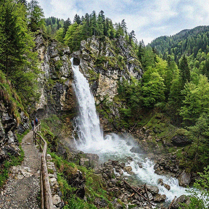
The dramatic focal point of the upper valley is the Pis del Pesio, though calling it a conventional waterfall does not capture what is actually happening beneath your feet. The Pis is a karst spring: subterranean water emerges straight from the rock face to form a spectacular cascade, especially during periods of spate and heavy run-off.
Because of this hydrology, timing dictates your entire experience. The phenomenon is at its most spectacular during the spring thaw, when melting snow feeds the underground channels and forces water out across the cliff. Outside the snowmelt period or after prolonged dry spells, the underground supply drops. When that happens, the waterfall can be completely dry.
The Pis del Pesio is a karst spring, not a permanent glacier-fed cascade. Outside the spring snowmelt or following prolonged dry spells, the flow can dwindle to a trickle or dry up entirely. If you want to witness the cascade in full spate, plan your trip for late spring or shortly after periods of sustained rain. Wet rock and steep grades also make proper hiking boots with stiff, lugged soles non-negotiable — leave city trainers at home.
Trails continuing from Pian delle Gorre towards Rifugio Garelli and the Marguareis massif#
Pian delle Gorre is not merely an endpoint for low-altitude circuits; it is the threshold to the high mountains. From the clearing behind the refuge, marked trails branch out towards Rifugio Garelli, climbing steadily above the tree line towards the limestone crags of the Marguareis massif itself, where serious mountaineers head for technical ascents and multi-day traverses through the karst plateaus.
For those seeking an alternative approach from lower down, you do not have to drive directly to the refuge. Starting from the Certosa di Pesio, an easy, signposted nature trail equipped with educational panels provides an alternative to walking along the tarmac road. This path ascends the Vallone di San Bruno, running directly alongside the old perimeter wall of the religious complex before climbing beneath the canopy all the way to Pian delle Gorre.
Technical data, gear, boots, the right season, and what can go wrong#
Taking on the waterfall loop requires basic trail discipline. An 8-kilometre route with 400 metres of ascent across 3 hours might look undemanding on paper, but the steep sections become slick when wet, and the trail demands genuine walking boots with good grip rather than light leisure footwear. Trekking poles will spare your knees on the descent steps, particularly when coming down from the steeper sections near the head of the loop.
My own miscalculation in Valle Pesio came on a mid-autumn morning when I arrived entirely focused on seeing the torrent of the Pis del Pesio without factoring in the karst system. After pushing hard up the final steep ascent on cold limestone — sweating through my base layer to beat incoming cloud — I reached the viewing ledge only to find absolute silence. The rock wall was bone dry; the spring had stopped flowing weeks earlier. Scrambling back down over slick roots while kicking myself for ignoring basic local hydrology was a firm reminder that mountains do not adjust their plumbing to suit visitor timetables.
Here is the essential breakdown for the loop:
- Starting point: Rifugio Pian delle Gorre car park
- Distance: Approximately 8 km
- Elevation gain: Approximately 400 m
- Estimated time: Around 3 hours
- Difficulty: Moderate (includes two steep, demanding ascents)
- Prime season: Spring during the snowmelt for full waterfall volume
Driving from Cuneo and connecting itineraries#
Reaching the trailhead by car is straightforward. From Cuneo, the drive to Chiusa di Pesio covers approximately 15 kilometres, taking about twenty minutes on open regional roads. From the centre of town, you simply follow the valley floor road as it climbs south into the mountains, first passing the Certosa di Pesio before finishing at the parking area of Rifugio Pian delle Gorre.
After spending a day navigating the cool shade and wet limestone of the Ligurian Alps, you can easily shift gears towards the rolling hills further north. Pair your alpine walking with the region’s culinary culture by following the wine roads of Piedmont an authentic guide to Barolo and Barbaresco, or spend a morning exploring rural traditions on foot through our guide to truffle hunting Langhe Piedmont guide.